
People fly from all over the world to hike in Patagonia.
People dream about the best hikes in Bariloche and El Chalten, but somehow Ushuaia is not on many people’s radars.
Sure, everyone gives the national park a whirl and hikes to Lagunga Esmeralda. But, my dear outdoorsy friends, that is just scratching the surface.
When you start to research trekking in Ushuaia you’ll discover enough day hikes (of varying difficulties) to fill a week or two.
Want to discover the best trails at the end of the world?
Then keep reading for the best day hikes in Ushuaia.

QUICK NOTE: This post contains affiliate links and Sol Salute may receive a commission for purchases made through these links, at no extra cost to you.
The Best Day Hikes in Ushuaia: Trekking at the End of the World
I find that the trekking in Ushuaia is underrated.
Most people visit for 3-4 days and move on to their next destination, but if you love hiking and the outdoors, you could easily fill a week or longer here.
There are hikes all along Ruta 3 beyond just Laguna Esmeralda, Tierra del Fuego National Park is houses a number of stunning views, and historic estancias across the province are home to their own private trails.
This post will help you plan your itinerary for hiking in Ushuaia.
Important Tips for Hiking in Ushuaia
- The weather in Tierra del Fuego is unpredictable. Check the forecast before hitting the trail but still pack layers for all conditions, just in case.
- Ushuaia, like all of Patagonia, is very windy and weather changes without warning here. Pack a good waterproof shell like this.
- Tierra del Fuego is very muddy, wear proper, waterproof hiking boots (I have lived in these Danner boots for 5 years and counting).
- For hiking poles you don’t need to invest much, we use this cheap set from Amazon and they’re great.
- Gear rental: If you don’t want to pack heavy boots or poles, you can rent gear from the many rental shops on Avenida San Martin downtown. We rented a child carrier from Cumbre Rental and found they had the best price and were the most responsive.
- How to get to the trailheads: Renting a car (check rates here) is the easiest way to get around, since there is no signal once you leave the city limits. If you’re on a budget, there are shuttles that leave from the bus terminal by tourist information in the port or you can take a taxi (make sure to arrange a pick up time in advance to return, remember, no signal).
Ushuaia Day Hikes Outside the National Park
Usually national parks at the epicenter for all the best trails, but Tierra del Fuego abounds with natural beauty.
The most beautiful day hikes aren’t limited to the national park.
Here’s a list of those hikes, mostly along Ruta Nacional 3 to the north of town.

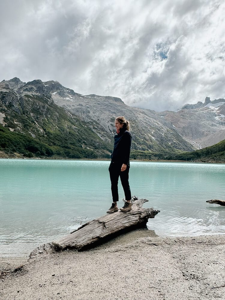
Laguna Esmeralda
Difficulty: Moderate
Length: 8.7 kilometers, there and back
Time Required: 4-5 hours
Laguna Esmeralda is the most popular of the day hikes in Ushuaia. The trailhead is on Ruta 3 around 20 minutes from town. You can’t miss the bustling parking lot.
The trail is listed as moderate in difficulty but I always find it to be relatively easy.
It is mostly flat (with the exception of one tiring ascent) and even has a lot of wooden pathways installed over the muddiest sections of the trail.
Like all of the hikes in Ushuaia, this trail can gets muddy and it does include some peat bogs.
We hiked this trail a second time in February 2026 and noticed the addition of a lot of wooden pathways since our first hike in 2021. While an immense help, there is still a lot of mud and I was happy for my boots.
This is the busiest trail in Ushuaia so I recommend going really early if you want to avoid crowds.
🥾For more, read my detailed complete guide to trekking Laguna Esmeralda.

Ojo del Albino Glacier
Difficulty: Strenuous
Length: 13 miles (21 km), there and back
Time Required: 10 hours
This hike is strenuous and hiring a guided excursion like this is recommended.
The trail 21 kilometers with 800 meters in elevation gain.
The Ojo del Albino Glacier is above Laguna Esmeralda, so the hike begins with that trail and continues beyond the laguna to ascend the mountain until you reach the glacier.
If the conditions are right you may be able to trek on the glacier. This is another huge reason to go with an experienced guide. Do not attempt to trek on the glacier without one.
Click here to reserve you Ojo del Albino excursion.
The package includes lunch, use of crampons and boots.
Read Next: Where to Eat King Crab in Ushuaia (+ How to Catch Your Own!)

Laguna Turquesa
Difficulty: Moderate
Length: 3 km, there and back
Time Required: 3 hours
Laguna Turquesa is a great alternative (or addition) to Laguna Esmeralda.
The trailhead is just a few hundred meters before Laguna Esmerelda’s on Ruta 3.
Unlike Laguna Esmeralda’s large parking lot, parking for this trailhead is more of an enlarged shoulder on the side of the road. Here is the Google Map pin for the trailhead.
Laguna Turquesa’s trail follows an old axmen’s trail so you’ll see cut trees recovering.
The hike is very short in comparison to Laguna Esmeralda but it is a bit more challenging. The entire way there is up and often slippery.
If it’s been raining it can be extremely muddy so I recommend wearing proper boots and using hiking poles. I did not remember poles and the muscles in my legs were shaking by the end of our descent.
🥾For more detail and photos of each portion of the trail, read my complete review of hiking Laguna Turquesa.
Estancia Tunel & Río Encajonado
Difficulty: Easy
Length: 4.4 km, there and back (11 km for the Encajonado River)
Time Required: 3 hours (5 hours if going to the river)
This easy there-and-back trail follows the undulating coast of the Beagle Channel and weaves through Tierra Del Fuego’s beautiful sub-Antarctic forests.
Featuring panoramic views of the water and mountains throughout the entire trail, this is a very rewarding hike.
After about a kilometer in the forest, you’ll reach a clearing that is ideal for a rest or picnic while you take in the views. As the trail continues you will cross a creek, walk along the coastline, and descend a gradual hill to the estancia’s gate.
Estancia Tunel is no longer functioning but is a beautiful remnant of Tierra Del Fuego’s history.
The trailhead is 12 kilometers east of Ushuaia at the end of a dirt road, click here for a Google map pin.
Río Encajonado – Option to extend – From the estancia you can keep hiking to reach the Encajonado River. If you do this, the entire hike will be 11 kilometers round trip (including the initial Estancia Túnel portion of the trail) and takes around 5 hours.
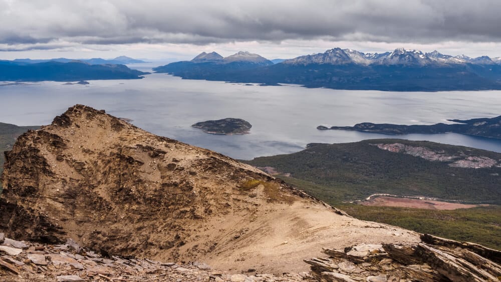
Glaciar Martial
Difficulty: Moderate
Length: 6 km (3.7 miles), there and back
Time Required: 3-4 hours
The Martial Glacier hike is 7 kilometers outside of downtown Ushuaia.
A lot of people suggest walking to the trailhead if you’re on a tight budget, but the road to reach the trailhead is 7 kilometers and straight uphill.
I, personally, would not want to walk that before hiking a 7 kilometer hike. Why make life harder for yourself? Drive to the trailhead or take a taxi.
The trail itself is short but steep. You will be going uphill the entire way to the glacier.
Thankfully, all of that effort is not in vain as this hike offers an incredible panoramic view of Ushuaia and The Beagle Channel.
At the top you’ll be exposed to the elements, this might not be the best trail for extremely windy days (of which there are plenty). Bring layers and a rain jacket.
PRO TIP: There are two great places to eat at the trailhead, reward yourself post hike → Refugio de Montaña and La Cabaña Casa de Té.
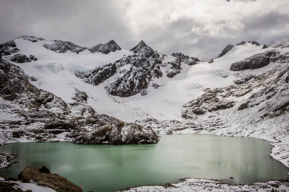
Glaciar Vinciguerra & Laguna de los Tempanos
Difficulty: Strenuous, Guided
Length: 13 km, there and back
Time Required: 8 hours
This is the main Ushuaia trek I want to do but haven’t been able to as I always have young children with me. This hike guarantees that I will return to Ushuaia.
It is a challenging hike and requires a guide, check this option out if interested.
The hike starts in the Andorra Valley and starts across a stretch of peatbog before reaching a forest. After the forest you’ll be exposed and it can be very cold so pack plenty of layers.
First, you’ll reach the Laguna de los Tempanos (Lagoon of the Icebergs). The group will continue hiking until you reach the glacier and its famous ice caves.
If conditions are right you’ll be able to explore the ice caves for a once in a lifetime experience.
Click here for more information and to reserve your Vinciguerra hike.
Ushuaia Hikes in Tierra del Fuego National Park
If you love hiking then you’re in luck, the best way to see Tierra del Fuego National Park is on foot.
Here are the best Ushuaia hikes in the national park.
Read Next: A Logistical Guide to Tierra del Fuego National Park

Senda Costera Trail
Difficulty: Moderate
Length: 8 kilometers, one way
Time Required: 2-3 hours
This was my favorite trail in the national park and I have that in common with just about everyone else who visits the park.
✉️Everyone who goes through the park stops here to at least visit America’s southernmost post office. Don’t miss that quirky landmark. Unfortunately, you can’t go inside as it has been closed for a couple of years (as of February 2026) but you can still see the building.
The Costera Trail is relatively easy, bordering the coastline of the Beagle Channel with stunning views of the mountains at every turn.
There isn’t really any elevation gain since this trail borders the coastline but there are some short steep sections here and there and it can get muddy (like every trail in Tierra del Fuego).
We didn’t hike this entire trail since we had our young toddler with us and a car in the main parking lot. Instead, we hiked half-way then turned around and went back the way we came.
Alternatively, don’t leave a car in the lot that you’ll need to return to. Take a taxi or shuttle and hike through the park.
Hiking Costera to the end will take you back out the main road by a bus stop (check with visitor information when you enter the park on the bus schedule) and the Alakush Visitor Center.

Sendero Hito XXIV
Difficulty: Moderate
Length: 7 kilometers, there and back
Time Required: 3 hours
The Hito XXIV trail is another trail that hugs a coastline, this time the shores of Lago Acigami (also known as Lago Roca).
The trail starts at the parking lot for the lake and ends at the border to Chile.
Like the Costera Trail, the difficulty level is technically moderate but overall it’s very easy.
There isn’t any elevation gain and it’s a great trail for families. I even managed to hike the entire trail with my toddler on my back and saw a family on the trail.
Most of this hike is in the forest so it’s a great option for hiking on windy or rainy days since you’ll be more protected from the elements than on trails like Costera.
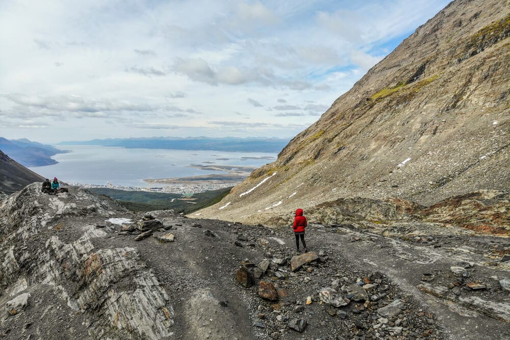
Cerro Guanaco
Difficulty: Strenuous
Length: 8 kilometers, there and back
Time Required: 4 hours
Cerro Guanaco is classified as strenuous because it is basically a steep, uphill climb for the entire ascent.
It can also be very muddy and portions of the hike traverse peat bogs. Definitely don’t attempt this hike without proper, waterproof hiking boots and poles.
You are required to register with the visitor center before starting this trail.
The trailhead is next to the start of Hito XXIV, instead of bordering the lake it forks off immediately to ascend the mountain.
The trail ascends through the forest until you clear the treeline. This final stretch is very exposed and the most difficult.
Once at the peak – at nearly 1,000 meters above sea level – you’ll have panoramic views of the national park, the mountains, and the Beagle Channel.


Short Hikes in Lapataia
Ruta Nacional 3 is the road that leads from Ushuaia to the national park.
The highway actually crosses the entire country, ending here at Lapataia Bay, also marking the end of the national park (at the end of the end of the world, one might say).
There are a number of short, easy hikes along Ruta 3 from the Alakush Visitor Center to Lapataia Bay.
These hikes range from as short as 20 minutes and upwards of an hour and a half. All are classified as easy.
The views do not disappoint and offer a great low effort/high reward ratio for those that don’t want to hike much but want to see the park or those that just finished a longer trail and want to chill.


Here’s a list of the 6 very short and easy trails in the Lapataia region.
Take the length of each with a grain of salt. I pulled these trail lengths from the park map but the signs nearly always said something different.
Sometimes the conversion from miles to km also makes no sense, so… which is right?
In reality, they’re all short and easy so it a few hundred meters here or there doesn’t really matter.
- Paseo de la Isla – 0.4 miles/800 meters – This was one of my favorite hikes in the park. It was gorgeous. The trail borders the Lapataia and Ovando rivers and the Cormoranes Archipiélago.
- Paseo a la Laguna Negra – 0.6 miles/950 meters – An easy hike to a laguna in a peatbog, the lagoon’s dark coloring comes from the peat.
- Mirador Lapataia – 0.6 miles/950 meters – Good views of the bay and since it connects to Turbal it’s a good way to reach Lapataia Bay on foot.
- Paseo del Turbal – 1.2 miles/2 km – Easy walk across a peatbog, it connects to the Castorera trail.
- Paseo de la Castorera – 0.2 miles/200 meters – This short walk is mostly on a boardwalk viewing the effects beavers have had on this ecosystem. There are information plaques about the invasive species (brought in from Canada) and how they’re being controlled. Definitely worth doing.
- Senda de la Baliza – A short hike at the Bahia Lapataia, you’ll see the trailhead fork off from the main boardwalk, great views of the bay.
In Summary: Ushuaia Trekking & Beyond
Tierra del Fuego is a rugged, isolated corner of the world. It’s unlike the rest of Patagonia and honestly, unlike anywhere else you’ll ever see.
We loved exploring the many day hikes in Ushuaia and can’t wait to return for more.
If you have any comments or questions, let me know in the comments! I always read and respond.
Read more about Hiking & Patagonia
- The Best Hikes in Argentina
- The Best Hikes in El Chalten
- Gorgeous National Parks in Argentina
- Where to see Wildlife in Argentina
- Things to do in El Calafate
- How to visit El Perito Moreno Glacier
- Skiing in Argentina: A Complete Guide
- Things to do in Puerto Madryn
Argentina Travel Resources
- BOOK A CONSULTATION | I offer one-on-one travel consultations to help you plan your trip to Argentina. Pick my brain to get a local’s insight. Click here for more information.
- MY MAP | Buy my interactive map with 300+ pins to have access to the city as I see it. It is an invaluable resource. See more here about how it works.
- AIRPORT TRANSFERS | Having a driver waiting for you is ideal for a stress free arrival, Cesar and his team here is the best option for a driver from Ezeiza or Aeroparque, they are my go-to airport ride!
- TRAVEL INSURANCE | Always travel insured. Anything can happen anywhere and it is scarier and costlier in an unfamiliar country. SafetyWing’s Essential Plan covers unexpected travel and medical emergencies and even offers add-ons like electronics theft or adventure sports. It is the best if you’re coming on vacation. If you’re coming as a digital nomad or an extended stay, you need their Complete Nomad Plan which also covers routine check ups, maternity, mental healthcare and more. Read more: Health Insurance in Argentina
- PHONE PLAN | These days, traveling with data is essential. Especially in Argentina where everything is managed on Instagram and WhatsApp. I recommend this E-SIM card. It’s hassle-free and affordable, for more read how to get an Argentina sim card.
- ACCOMMODATION IN ARGENTINA | booking.com is the most common hotel site used in Argentina and it’s where you’ll find the most options.
- RENTAL CARS | I love using Discover Cars, it is a great platform to compare different rates and providers and I find they have responsive customer service.
- BUS TICKETS | Check Busbud for long distance bus routes and tickets.
- VPN | If you’ll be using a public WiFi connection and want to secure your data, I highly recommend using a VPN, I personally use and have had a good experience with ExpressVPN. I also use it to access Hulu and American Netflix from Argentina.
- FLIGHTS | Always check Google Flights and Skyscanner for flights to and within Argentina. Aerolineas Argentina is the local airline with the most routes. FlyBondi and Jetsmart are two budget airlines with dirt-cheap prices (but expect to pay for every add-on like luggage).

Thank you for sharing your experiences. I have read many of your articles here to prepare for my very first trip to Argentina at the end of November. We will spend 4 days in Ushuaia and plan to go hike 3 of the trails in your article. They are all couple hours long hikes. I am wondering about the bathroom situation on these hikes? Do people just go in nature? Are there toilets at the beginning or the end of the hikes?
There is one bathroom in the national park in the Arakush visitor’s center, otherwise yes, you’d need to go in nature. If you use any toilet paper/tissue, pack out what you use (bring a small plastic bag to bring out trash).
Thank you for your sharing your experiences. we are going to hike Tierra del Fuego National Park next month. Do you have any shuttle information? is it possible to hike Senda Costera to visit center and hope on shuttle to the end stop and hike Mirador Lapataia, Del Turbal…
thanks
Hi, thanks for all the great info you are sharing!! We are planning to visit next March and have a similar question to what was asked by Wei. Is there a way to do the Senda Costera hike all the way and then take public transport back to your car. We are planning to rent one. Thanks!
You can hitch hike back to your car
hi there, would you recommend ushuaia or salta area more